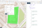


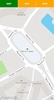
Discover the precision and convenience of a sophisticated GPS recording tool designed for capturing polygon vertices and calculating spatial dimensions with ease. GPS recorder of polygon with ease serves a dual purpose: it is both a polygon GPS registrar and an area and perimeter calculator. Empower users to capture accurate geographical data through the mobile GPS receiver, ensuring the precise registration of vertices within the parameters set for accuracy and distance thresholds.
Ideal for tasks requiring at least three vertices to measure an area, this app shines in its ability to accurately calculate and record the perimeter of a polygon. The intuitive calculator seamlessly connects the first and last vertices, allowing for an intricate determination of the area as well as the perimeter. Once measurements are conducted, there is an option to save the collected data in the versatile GeoJSON format, promoting ease of use for further analysis or conversion.
Benefit from the flexibility to activate the GPS receiver only when needed, which helps conserve device resources. Moreover, the tool boasts offline mode functionality, a crucial feature for use in rural settings or regions with limited connectivity, such as deserts. The data visualization process is straightforward—use online tools to display the GeoJSON file content on a map, edit, or even convert it to other popular formats like KML, WKT, or TopoJSON. Additionally, for comprehensive projects, compile multiple JSON files into a single document using external software.
Embrace the reliability of GPS recorder of polygon with ease, an essential tool for professionals in the field of geography, environmental management, urban planning, or any discipline that demands precision in area and perimeter tracking.
Requirements (Latest version)
- Android 4.1, 4.1.1 or higher required
Comments
There are no opinions about GPS recorder of polygon with a yet. Be the first! Comment